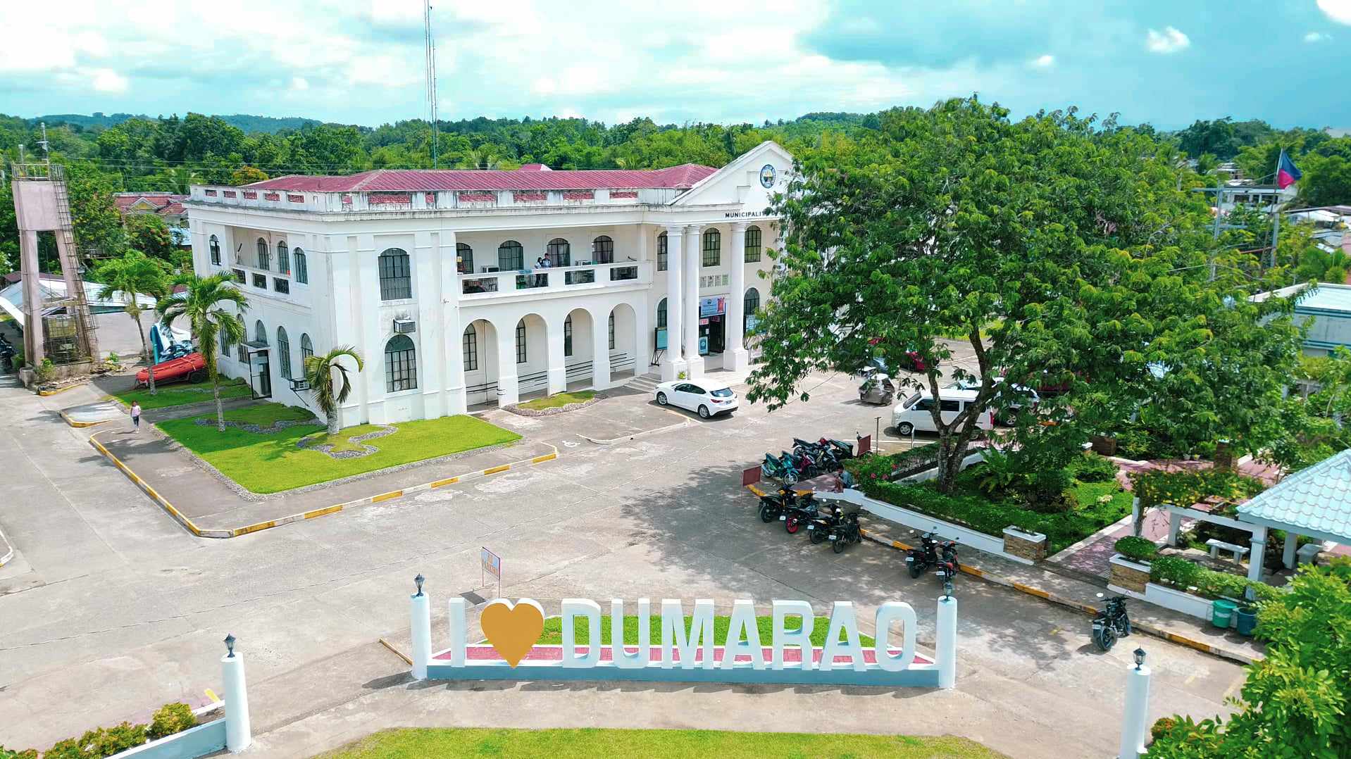
About Dumarao

Dumarao is the third largest municipality in the province of Capiz. It has a land area of 23,420.32 hectares. Its population as determined by the 2020 Census was 49,506. This represented 6.15% of the total population of Capiz province. According to the data, the population density is computed at 211 per square kilometer.
The dominant economy of Dumarao is agriculture. It has 15,411.98 hectares of fertile agricultural land.
The agricultural products of the municipality include rice, corn, sugarcane, vegetables, coconut, root crops, bananas, and seasonal fruits.
Dumarao Summary Data


Legend
The town got its name from the first Spanish colonizers who set forth in the municipality. One sunny day, these foreigners passed by an old farmer’s family drying rice in the front yard. One of them approached the head of the family and inquired about the name of the place. Presuming that the Spaniard had asked for the variety of rice being dried, the native replied “Araw”. Since then, during the Spanish time, the place was referred to as “Dum-araw”, “dum” being the Latin equivalent of the Spanish “donde”, meaning “where”. Thus, Dumaraw means “the place where there is araw”.
Background
Dumarao was Established as municipio in 1581, 60 years after the Spanish conquistadores had landed on Visayan shores, and as an independent parroquia in 1690 with Rev. Father Pedro Porras as its cura-parroco. The earliest known presidente-municipal (Municipal Mayor) is Jose Arancillo (1890).
In 1898, the struggle for independence from Spanish rule compelled some Dumaraonons to enlist as Katipuneros with Gen. Quintin Salas, commander of the revolutionarios in Panay.
The American regime introduced the public school system in the town in 1903, with John Langhran as Principal Supervisor. A notable product of the American Educational System was Ludovico Hidrosollo, a government scholar to the U.S.A., who, shortly after his return from his studies, became a Philippine Senator for Cultural Minorities and later the first Dumaraonon to become governor of Capiz.
With the outbreak of World War II, a military landing field was put up in Brgy. Salcedo which was eventually strafed by the Japanese. Houses in the poblacion were burned intentionally to prevent the Japanese from residing in town. Lt. William Haguisan Abellano was awarded the Purple Heart Medal by the U.S.A. President and the Congress for heroism in action. Col. Terasaki, “the Terror of Panay”, was ambushed and killed in Brgy. Tinaytayan by Dumaraonon soldiers.
The 1945 Philippine Independence ushered the holding of national and local elections. Since then, Dumarao political leadership has been wielded longest by the Benjamin family: Ramon Arancillo Benjamin, Sr., Heracleo Montemayor Benjamin, and Leslie Warren Alianza Benjamin. The lineage of leadership also includes Gaudencio Benjamin Arancillo, Sr., Angel Advincula Salcedo, Sr., Agapito Holmena Ojacastro, Gaudencio Mirasol Arancillo, Jr., Victor Arancillo Tanco, Sr., Heracleo Montemayor Benjamin, Leslie Warren A. Benjamin, Edgardo Mirasol Arancillo, and Atty. Mateo Concepcion Hachuela.
History
The Pre-Spanish Period
The native residents were Malayans, who had come in sailboats, called balangai, via Palawan Island, turning in westwardly direction into the Visayan Sea and, presumably, landing in the seashore of Agoho, Pan-ay. In search of fertile agricultural and pasture lands, they moved southward by row boat and settled in Sitio Dangula, now a barangay, where the Badbaran and the Panay rivers meet. The settlers relied on these two rivers for fish and transportation and on the lush forests for root crops, such as kayos, balinghoy, gabi and vegetables. They thrived on the abundance of boars, fowl, and deer in the nearby forests of what are now known as Codingle, Terum, and Tamulalod. Fresh water fishes in Balogo, Linao, Pandong, Bungsuan, and Lawaan, drew them farther inland to settle in the present site of the Poblacion. They cleared it of its timbers, with which they built their houses of wood, bamboo, and cogon grass.
The Spanish Period
The government was patriarchal in orientation, more or less a family grouping for assistance during emergencies, calamities, and construction projects. Later on, the Barangay social structure was assimilated for cohesion and administration.
For clan or family identification, surnames were issued in accordance with the order of the Spanish Governor-General. Each town was given an initial letter of the alphabet. Dumarao had the letter “H” – thus, any family surname in this town with the initial “H” is an original native of the town.
During this period, Astorga, Lawaan, Tina, Tinaytayan, Alipaciawan, and Janguslob were established as barrios.
THE REVOLUTIONARY PERIOD
1892-1898
Several attempts were made by the revolutionarios from Sara and Dumangas to organize revolutionary groups. But, people were not receptive to the idea either because of their loyalty to the Spaniards or because of the futility of such an enterprise. However, in 1898, General Quintin Salas passed the town on his way to Kalibo, Aklan. He organized a revolutionary nucleus at the residence of Hermogenes Advincula.
Alerted, the Spaniards arrested Hermogenes Advincula, Filomeno Falle, Placido Hibaler, Liberato Haguisan, and Santiago Rubrico. Serafin Advincula was able to escape. They were brought to Capiz and imprisoned. However, on the guarantee of Sgt. Miguel Lazaro, brother-in-law of Liberato Haguisan, they were released on September 13, 1898. The Presidente Municipal Jose Arancillo, declared that day a municipal holiday with appropriate ceremonies.
THE AMERICAN PERIOD
The American government was established in the Philippines in 1900. From 1900 to 1903, military rule predominated. The military established the educational system in Dumarao, with John Langhran as the Principal Supervisor and George Sheens as Superintendent. Among the pioneer pupils were Ludovico Hidrosollo, Pablo Advincula, Candelaria Herbolario, and Maria Cabailo. The last three became teachers when the American teachers withdrew from classroom instruction. They were tutor-pupils because they taught as they learned.
Cholera epidemic struck in 1908.
The Philippine National Railway, which the Americans had started constructing, reached Dumarao in 1909. Kipot (now Bato),now a sitio of Barangay San Juan, was the proposed site of the railway station, but this being too far from the Poblacion, the station was brought nearer to the town proper on the land donated by the Salcedo Family – that is how Barangay Salcedo got its name.
The Presidente-Municipal in 1907 was elected only by the consejales. Capitan Serafin Advincula was elected. He donated the present municipal cemetery. He created Villa Advincula in Brgy. Astorga and Villa Hidrosollo in Brgy.Gibato.
A severe typhoon named locally as Bagyo Ugis, lashed the town in 1912 destroying crops and property.
The Beginning of Partisan Politics
After the term of President- municipal Serafin Advincula, Jose Arancillo was elected by agreement to take his turn. Unfortunately, President Arancillo died of heart failure in Passi, Iloilo before his term expired. His brother, Miguel Arancillo, was elected over the vehement objection of Capitan Presidente Serafin Advincula, who contended that the agreement was by alternate succession, and that Abundio Advincula, his brother, should succeed Jose Arancillo. The “consejales”, however, stood firm with their choice of Miguel Arancillo as successor to Jose Arancillo, who served then as Municipal Secretary.
In 1913, general popular election was introduced. Two political parties emerged: Democrats and the Nationalistas. The Democrats were headed by Serafin Advincula while the Nationalistas, by Miguel Arancillo, was elected Presidente-Municipal.
The previous leaders of Dumarao have proven themselves worthy of their administration. Significant programs and projects were implemented which creates recognizable contribution to development. There are initiated programs that up to the present were embraced and continually adopted because of the importance it had given to the Municipality.
The development oriented local officials envisions a competitive and self-reliant community. Whereas priority programs and projects are centered for development that will ease and improve the lives of the people, protect biodiversity and ecosystem.
Geo-physical Hazards
Thirty (30) barangays are susceptible to rain-induced flooding. The high category for rain-induced flooding includes 49.01 hectares or 0.02% of the municipality’s total land area. Moderate susceptibility covers 133.87 hectares (0.57%), whereas low susceptibility covers 5,336.13 hectares (22.78%).
All 33 barangays are susceptible to rain-induced landslides. An area of 5.25 hectares, or 0.02% of the municipality’s total land area has high susceptibility. The combined areas with high susceptibility comprise 3,709.85 hectares or 15.84%; whereas 16,648.09 hectares, or 71.08% under low susceptibility.
All lowland barangays of the municipality and portions of barangays Agsirab and Bungsuan have high subsidence susceptibility comprising 8,642.69 hectares or 36.90%.
Seventeen (17) barangays are prone to liquefaction and have a total area of approximately 1,438 hectares or 6.14%.
The 33 barangays are susceptible to ground-shaking during an earthquake with intensity (PEIS) VI to VIII.
Geographic Profile
Demographic Profile of Barangays


Location
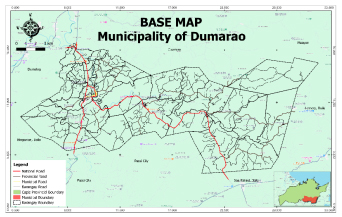
The municipal center of Dumarao is situated at approximately 11° 15.733’North, 122° 41.226’East, in the island of Panay. Elevation at these coordinates is estimated at 29.6 meters or 97.1 feet above mean sea level.
Demographic Profile
Households
In the 2020 Census, the household population of Dumarao was 49,506 broken down into 12,775 households or an average of 3.87 members per household.
Population by age group
Based on the 2020 Census, the age group with the highest population in Dumarao is 10 to 14, with 4,926 individuals. Contrarily, the age group with the lowest population is 75 to 79, with 641 individuals.
The combined age group of individuals aged 14 and below, consisting of the young dependent population which includes infants/babies, children, and young adolescents/teenagers, make up an aggregate of 29.11% (14,403). Those aged 15 up to 64, the economically active population and actual or potential members of the workforce, constitute a total of 63.14% % (31,236). Finally, the old dependent population comprising senior citizens aged 65 and over, totals 2.82% % (1,397).
Historical population
The population of Dumarao increased by 44,027 people in 117 years from 5,479 in 1903 to 49,506 in 2020. The latest census figures in 2020 denote a positive growth rate of 1.49%, or an increase of 3,349 people, from the previous population of 46,157 in 2015.
Distances
Nearest towns
- Dumalag, Capiz, 8.50 kilometers (5.28 miles) to the West-Northwest (N58°W)
- Cuartero, Capiz, 8.83 kilometers (5.49 miles) to the North-Northwest (N13°W)
- Bingawan, Iloilo, 13.49 kilometers (8.38 miles) to the West-Southwest (S76°W)
- Dao, Capiz, 14.45 kilometers (8.98 miles) to the North (N1°W)
- Tapaz, Capiz, 16.36 kilometers (10.16 miles) to the West (S89°W)
- Maayon, Capiz, 17.14 kilometers (10.65 miles) to the Northeast (N37°E)
Nearest cities
- Dumalag, Capiz, 8.50 kilometers (5.28 miles) to the West-Northwest (N58°W)
- Cuartero, Capiz, 8.83 kilometers (5.49 miles) to the North-Northwest (N13°W)
- Bingawan, Iloilo, 13.49 kilometers (8.38 miles) to the West-Southwest (S76°W)
- Dao, Capiz, 14.45 kilometers (8.98 miles) to the North (N1°W)
- Tapaz, Capiz, 16.36 kilometers (10.16 miles) to the West (S89°W)
- Maayon, Capiz, 17.14 kilometers (10.65 miles) to the Northeast (N37°E)
Distance from Manila
412.09 kilometers (256.06 miles) to the North-Northwest (N26°W)

